

SASRI is making increasing use of digital platforms to enhance its research and service delivery.
Data collection
Until recently, SASRI relied on traditional paper-based templates for in-field data capture, which increases the risk of errors, redundancy, inconsistency and data loss.
A digital platform, using ArcGIS Survey123 software, is in the process of being developed to enable:
• in-field capture of data in a digital format (smart forms),
• seamless integration of these data into coherent databases; and
• geo-spatial display and interpretation of data as required.
A further advantage offered by this digital platform is that complex calculations can be automated, thereby removing a further potential source of in-field error.
Emphasis is being placed on the development of an app that can be used by growers, biosecurity staff and other stakeholders for collecting information related to the yellow sugarcane aphid (YSA). An early version of the app is currently being tested by SASRI extension, biosecurity and plant breeding staff.
Geo-spatial information
SASRI researchers require accurate geo-spatial information of its six SASRI research stations to design, implement, manage, and analyse their field experiments. Previously, the research station managers, researchers and technical teams used various versions of paper-based research station maps, some of which were outdated
A webGIS digital platform has been developed to enable the sharing of spatial information (such as trial design and layout) amongst projects and the promotion of potential collaboration and sharing of resources.
A user manual for the app has also been developed and training has already been provided to some research station managers. The app has already proved extremely useful in identifying reasons for flooding in some fields on the Empangeni Research Station.
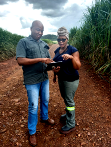
Musa Mchunu (Pongola Research Station Manager) receiving training on digital data collection from SASRI’s GIS and Remote Sensing Research Specialist, Ingrid Thompson.